Special Weather Statement SPECIAL WEATHER STATEMENT - Haywood  - Buncombe  - Northern Jackson  - Southern Jackson
Updated : Jun-07-2025 @ 2:55pm  
Temperature Current Conditions Forecast / Storm Prediction
Trend :Warmer 1.7°F than last hour.°F/hr

74.7°F

24hDiff °FNo Change
High Today
76.0°F
2:29 PM
Low Today
63.4°F
12:20 AM
Yest High
81.1°F
3:49 PM
Yest Low
62.1°F
7:04 AM
Sta* High
85.9°F
2008
Sta* Low
52.8°F
2012
* This Station's Records Since  3/2006
Dry Dry

Wind from E Wind :  E
0.9

Gusting to :
0.0 mph
Current Rain Rain:
0.09 in
Chandler Burning Index: LOW Current CBI
Fire Danger :
1.6 of 100
This
Afternoon
This Afternoon: Slight Chance Showers And Thunderstorms
Slight Chance Showers And T-Storms
Tonight

Tonight: Showers And Thunderstorms
Showers And T-Storms
Sunday

Sunday: Patchy Fog
Patchy Fog
Hi 82°F Lo 62°F Hi 79°F
SPC Activity Map
Dew Point Liquid Precipitation Wind Speed Sun/Moon
Current: Decreased 0.1°F since last hour. 67.4°F
Last Hour: Decreased 0.1°F since last hour. -0.1°F
High 2:29 PM: 69.7°F
Low 12:14 AM: 62.6°F
Record High: 78.3°F on
Jul-6-2022
Record Low: -11.0°F on
Feb-19-2015
Wetbulb: 69.9°F
Rain Today
rain graph

Today: 0.09 in
Storm Rain: 0.15 in
Yesterday: 0.06 in
Last 7 Days: 0.06 in
Jun Rain: 0.15 in
Jun to Date
  Avg:10
0.69 in
Jun to Date
  Diff from Avg:10
Under 0.54 in for the month 0.54 in
Jun Avg: 4.31 in
Diff from Avg: Under 4.16 in for the month 4.16 in
Season:1 29.06 in
YTD
  Avg:11
29.83 in
YTD
  Diff from Avg:11
Under 0.77 in for the year 0.77 in
Last Rain
Time/Date:
Jun-7-2025
at 6:04 AM
62 rain days in 2025
2 days in June
0 days since last rain
Current: E  0.9 mph
1Hr Average: 1.8 mph
Wind Run: 19.88 miles
Wind Gust
Current: 0.0 mph
Today: 11.5 mph 6:38 AM
Month: 13.0 mph Jun-1
Year: 32.2 mph Mar-15
Record Gust: 42.6 mph
Oct-29-2020
Sunlight:
14 hrs 28 min
56 sec
of Sunlight Today
Which is 41 sec longer than
yesterday
(Noon ?>) graph (Midnight

Waxing Gibbous
Waxing Gibbous, 11 days, 15 hours, 55 minutes in cycle
89%
Illuminated
Humidity Barometer
Current: Decreased 5% since last hour. 78%
Last Hour: Decreased 5% since last hour. 5%
High 1:08 AM: 99%
Low 2:41 PM: 74%
Record High: 100%
Nov-2-2007
Record Low: 11%
Mar-16-2015
Current: Falling 0.009  inHg/hr 29.786 inHg
Last Hour: Steady
High 12:01 AM: 29.876
Low 7:37 AM: 29.772
Record High: 30.900 inHg
Jan-3-2008
Record Low: 26.494 inHg
Sep-6-2021
Cooling Degree Days Lightning Strikes Heat Index Air
Today: 0.1
Jun: 8.1
2025 to Date: 39.4
Heating Degree Days
2025 to Date: 2658.0
Last Min: 0
Last 5 Mins: 1
Last 30 Mins: 1
Last 60 Mins: 1
Last 12 Hrs: 73
Jun: 229
2025 to Date: 87758
Last
Strike:
14:50:04
Jul-06-2025
Current: 75.5°F
High 2:29pm: 76.0°F
Yesterday: 84.8°F
Record: 98.4°F
Jun-13-2022
Quality
Index6:

61


Moderate
Density:
1.17 kg/m3
Current UV Index Current Solar Energy9
2.4
Sunburn in
47 Minutes
Highest:
1:48 PM
10.2
139 W/m2
100%
W/m2 SI
High Today:
2:04 PM
794  W/m2
Record:
1332 W/m2
Almanac Irrigation Index5 Station All Time Records Cloud Level
Currently: Afternoon
YTD Avg Temp: 47.8°F
Sunrise: 6:16 am
Sunset: 8:45 pm
Moonrise: 5:45 pm
Moonset: 3:39 am
Full Moon: Jun-11-2025
New Moon: 10:32 UTC
Jun-25-2025
Updated at Midnight
Current ET: 0.09 in
7-Days Rain: 0.06 in
7-Days ET: 0.50 in
7-Day:  0.44 in water in deficit of what evaporated in last 7 days. 0.44 in
June:  0.35 in water in deficit of what evaporated this month. 0.35 in
Support this Site!
Your donation helps support this site
HIGHS: LOWS:
89.4°F
Jun-30-2012
-5.3°F
Jan-7-2014
Daytime Records
  85.8°F°F
Jul-01-2012
  5.9°F°F
Jan-07-2014
Nitetime Records
  75.6°F°F
Jul-01-2012
  0.3°F°F
Jan-07-2014
ICN:5 | S3C2:3 | Ajax 3.xx
ISS:Ok | CON:4.6 | RCP:100%
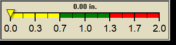
1 Rain season: Jan 1st to Dec 31st.   5 Estimated amount of water needed to replace the water used by plants and evaporation from the past week. (Negative numbers mean amount of water needed, positive numbers mean excess water is present).   6 Air Quality Index is provided by WNC Regional Air Quality Agency and is updated hourly between the hours of 6AM and Midnight.   9 Solar Index represents either an absolute scale of solar energy (W/m²) using the station’s recorded maximum or a percentage of computed theoretical solar maximum using the station’s location and time of day. These indices differ most when the sun is low on the horizon. The current scale is shown, and will toggle if it or the icon is clicked.   10 Historical average only to day 7 of just the month of June for this station since 2007.   11 Historical average rain this season to day 7 of June for this station since 2007.
 NWS Weather Forecast  -   Outlook This Afternoon & Tonight
This
Afternoon
This Afternoon: Slight Chance Showers And Thunderstorms
Slight Chance Showers And T-Storms

Hi 82°F
NWS forecast: A slight chance of showers and thunderstorms between 3pm and 4pm. Partly sunny, with a high near 82. West northwest wind around 9 mph. Chance of precipitation is 20%.
Local station forecast: Mostly cloudy and cooler, precipitation possible within 12 hours, possibly heavy at times, windy.
Tonight

Tonight: Showers And Thunderstorms
Showers And T-Storms

Lo 62°F
NWS forecast: Showers and thunderstorms before 4am, then showers and thunderstorms likely between 4am and 5am, then a chance of showers and thunderstorms. Mostly cloudy, with a low around 62. West southwest wind around 7 mph. Chance of precipitation is 80%. New rainfall amounts between a quarter and half of an inch possible.
ajax-dashboard6.php - Version 6.95h - 20-Feb-2023 - Script by: Scott of BurnsvilleWeatherLIVE.com
Now supported by Saratoga-weather.org Download